Historically field data collection was a daunting task reserved for geographic information specialists (GIS) professionals, and the technical savvy crowd. This was largely due to the learning curve involved in operating mapping grade Global Positioning System (GPS) receivers. However, smart phones and tablets have changed that. They offer an amazing array of functionality in a portable, intuitive and ever more familiar interface. Think about all the technology packaged into one of these little devices:
- GPS
- Camera
- Network connection (3G, 4G, WiFi…)
- Internet
- Apps
They're actually better than the Tricorders we used to see on StarTrek! They have a slimmer profile, probably weigh a lot less, have touch screens, bigger displays and can be used with thousands of available apps. One big question when considering smart phones or tablets for field data collection is, "How accurate are they?" A related question that must be answered is, "What kind of accuracy will meet the needs of my project?" You need to answer both of these questions to determine whether or not this technology will work for you. Usually survey grade GPS accuracies (sub meter or sub centimeter) aren't necessary for public health mapping. Getting within 10 meters is more than adequate to map facility locations, patient addresses, potential sources of disease or wellness. How Does GPS Work?The Global Positioning System (GPS) is a U.S. Department of Defense (DOD) system. It utilizes a constellation of 24 satellites orbiting the earth at an altitude of 12,000 miles. GPS devices compute your position by determining the distance between the GPS receiver and a minimum of 4 GPS satellites. The satellites transmit radio signals to the GPS receivers, allowing the calculations to occur. Initially GPS was established as a military guidance system, and I doubt anyone foresaw the popular use it has today.The iPhone has been equipped with an onboard GPS since the iPhone 3, and Android phones became GPS enabled at about the same time. Typically people use GPS to find restaurants and street directions. However, there's no reason these same devices can't be used for public health data collection!More About Smart Phone Locational Services Smart phones in fact use more than GPS to locate you. They employ a hybrid locational system combining three separate technologies:
- Assisted GPS (A-GPS)
- WiFi positioning
- Cellular network positioning.
These three technologies are used in combination as they are available. A-GPS is the most accurate of the three, and cellular positioning the least accurate. The figure below shows an example of the accuracy of each of these locational services.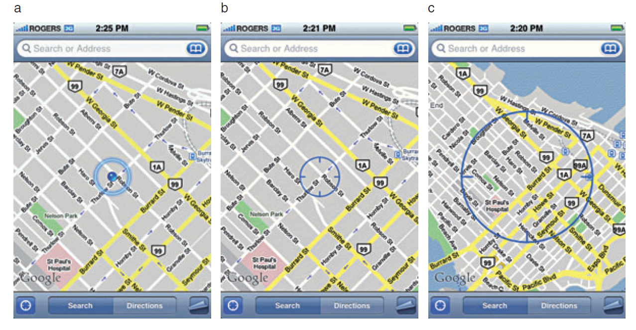 GPS AccuracyThere are a number of factors that affect accuracy no matter what GPS receiver is being used. The GPS radio signals encounter differing conditions while travelling through the atmosphere, causing signal delays, and therefore affecting accuracy. The geometry of the satellites being used will also vary. The GPS will have a wider array of satellites to choose from if you're out in the middle of a big field, versus being on 6th Avenue in Manhattan. You will get better positions if the satellites you're locked onto aren't clustered in one part of the sky. Therefore the more sky view you have, the more accurate your GPS will be. In addition to blocking your view of the sky, urban canyons can also cause multipath effects, where the GPS signal bounces off of buildings or other objects reducing accuracy.In part 2, I'll discuss each of the three pieces of the hybrid locational system individually, and discuss exactly what kind of accuracy you can expect to achieve.